
- Prologue
- Geography: CDS vs CSAT and CAPF of 2013 year
- Geography: CDS(I) vs (II) 2013
- Geography: CDS(II)2013 paper itself
- Geography: Topicwise Breakup
- Physical Geography answers
- Indian Geography answers
- World Geography Answers
- Geography: Agriculture/soil answers
- Environment and Biodiversity (EnB)
Prologue
- Preamble to the Constitution is a key to open the mind of the makers. Similarly previous papers of CSAT, CAPF and CSAT = keys to open the mind of the examiner.
- My point/conspiracy theory being: UPSC is using same question bank from its computer database to generate MCQs for all three exams-only the difficultly level varies a bit. Hence by studying these papers, one can get an idea of what type of information/topic to focus while reading a book/article.
Geography: CDS vs CSAT and CAPF of 2013 year
- Love for Agriculture continues.
- CSAT 2013: they ask about laterite soil and crop seasons
- CAPF 2013: they ask about black soil, micronutrients etc.
- CDS(II)2013: Here they’ve asked about laterite soil and red soil. Anyways good thing: you can solve ’em directly from NCERTs.
- Love for one tough question on Geology/rocks
- CAPF 2013, they’ve in tough question from rocks/geology of gondwana system
- CSAT 2013: occurrence of Mica, Petrol and Gas asked.
- CDS(II)2013: petroliferous rock.
- Day night
- CSAT2013: why Variations in the length of daytime and night time?
- CDS(II)2013: Circle of illumination
- Narmada-prem continues
- CSAT 2013: they ask why Narmada river flows to the west?
- CDS(II)2013: they’ve asked where does Narmada originate from?
- Disaster-prem continues
- CSAT 2013: the thunder in the skies is produced by the__?
- CDS(II)2013: extra tropical cyclone
- Love for North Atlantic map
- In CAPF 2013, they asked which current mixes with Labrador Current.
- In CDS(II) 2013, question about Sargasso sea- which is in the same map region.
- Love for hydroelectric project
- like CAPF 2013, there is question related to Hydroelectric Project
Geography: CDS(I) vs (II) 2013
As you know, CDS is conducted twice a year: CDS(I) and CDS(II) What is the pattern/similarly here
for the two exams held in 2013
| CDS(I) 2013 | CDS(II) 2013 |
| planetary winds that blow from the sub-tropical high pressure belts to the equator are known as | where do westerlies originate from? |
| Which parts of the earth’s surface experience least variation in incoming solar radiation throughout the year? | when is albedo effect maximum? |
| International Date Line is not correct | circle of illumination |
| deposits in Karewas of Kashmir | Why Himalaya poor in minerals? |
| where does Negrito tribe called the Onge live? | nothing in CDS(II) but similar question in CSAT |
| one MCQ on river origin | again one MCQ on river origin |
| Match Dam vs river | find hydroprojects on map |
Geography: CDS(II)2013 paper itself
- At least 4 MCQs can be directly solved from NCERT= Cost: benefit is extremely good, but rock solid revision necessary.
- Five MCQs were map based: Sanctuaries, hydro projects, rivers north to south, landlocked country in Africa, Sargasso Sea. Perhaps because UPSC wants to see whether future army/navy/airforce officer is proficient in map reading or not? Either way, you need to prepare the maps- at least Indian physical and political.
- 5-6 questions were odd/tough (in the sense, I couldn’t quickly pullup answer from standard reference books/net.) but then again you don’t need to tick 120/120 in CDS paper to get selected. so, don’t dig graves in negative marking by ticking answers you’re unsure of.
- In terms of current affairs related geography- one MCQs on “Nathu la Pass was opened in 2006.” but then again, not worth the majoori in terms of Cost: benefit.
Geography: Topicwise Breakup
Within geography
| Geo_Physical | 9 |
| Geo_Indian | 8 |
| Geo_World | 4 |
| agri | 2 |
| total Qs in CDS(II)2013 | 23 |
Overall in CDS exam
| Topic | 2013(I) | 2013(II) |
| Science | 28 | 23 |
| History n Culture | 18 | 26 |
| Geography & Agriculture | 15 | 23 |
| Economy | 14 | 16 |
| Polity | 14 | 11 |
| International affairs | 10 | 6 |
| EnB | 7 | 3 |
| Defense related | 0 | 1 |
| Misc.GK, Sports, Awards etc. | 14 | 11 |
| 120 | 120 |
anyways, let’s solve the questions. Any correction/addition- post in the comments, avoid Wikipedia.
Physical Geography answers
1. Chinook is a:
- cold wind in Europe
- tropical desert storm in West Asia
- warm wind in North America
- depression in South Africa
- NCERT Class7 “Our Environment”, Chapter 9, Page 66: (under Prairies in North America)- Due to the absence of the north-south barrier, a local wind “Chinook” blows here.
- Tata Macgrawhill General Studies Manual: under Indian and world geography section: Chinook, blowing eastwards down the slops of Rocky mountains, leads to quick melting of ice in the central plains of USA.
- Page 111 Goh Cheng Leong: It is a warm and dry local wind blowing in leeward side of Rockies mountain of N. America. Chinook is also called as snow eater.
Hence answer (C)
This was also asked in recent MPPCS geography mains (3 marker)
2. The humidity of air measured in percentage is called:
- absolute humidity
- specific humidity
- relative humidity
- all of the above
Page 98, chapter11 (NCERT class 11 Fundamental of physical geography) 2nd paragraph. Hence Answer (C)
3. Composite volcanic cone is also called strata cone because of the:
- alternating sheets of lava and pyroclastic materials
- uneven streams of lava flow
- cataclysmic eruption
- eruption of lava flow from a fissure
NCERT Class 11 Physical Geography, Ch3. Page 27:
Composite Volcanoes: These volcanoes often result in explosive eruptions. Along with lava, large quantities of pyroclastic material and ashes find their way to the ground. This material Accumulates in the vicinity of the vent openings leading to formation of layers, and this makes the mounts appear as composite volcanoes.
Other sources:
- Tata Macgrawhill General Studies Manual under Indian and world geography section page 54
- Goh Cheng Leong– page 22 last para:
- Physical geography SAVINDRA SINGH: Page 124
Hence answer (A)
4. Albedo effect would be relatively higher in:
- early morning and late evening
- early morning only
- noon
- late evening only
- NCERT Class9 talks about Albedo but remains silent on “when it’d be relatively higher”. Time to move to next source:
- Tata Macgrawhill General Studies Manual Page 18 under Indian and World Geography: Albedo also varies according to the angle of incidence of the Sun Rays-being higher for slating rays and lower for vertical or nearly vertical rays.
- From this info, we can derive that albedo will be relatively higher during early morning and late evening because at both times, Sun rays are slanting. Hence Answer (A)
5. Which one among the following statements is not correct?
- Solar noon occurs simultaneously at locations with the same longitude
- One meridian, which is directly under the sun, experiences solar noon at a given time
- Places having same longitude experience solar noon at different times
- Solar noon occurs at different times at locations with the same latitude
Solar noon is the time when sun is crossing the observer’s meridian.
- Question statements are lifted from Physical geography by Alan Strahler & Arthur Page 50-51
- Solar noon can occur simultaneously only at locations with same longitude. In other words, only one meridian can be directly under the Sun and experience solar noon at a given moment.
- Anyways, since it says Solar noon can occur simultaneously only at locations with same longitude= Statement “C” is wrong. Hence answer “C”.
6. Oil is found in petroliferous rock. Which one among the following structures demonstrates an ideal trap?
- Horizontal structure
- Fault structure
- Synclinal structure
- Anticlinal structure
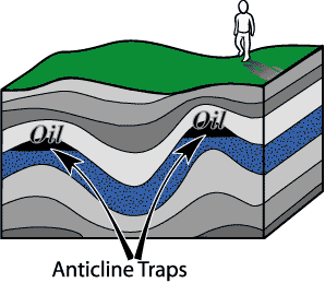
Britannica: http://www.britannica.com/EBchecked/topic/454269/petroleum/50713/Accumulation-in-reservoir-beds#toc50715
The most common structural traps are anticlines. About 80 percent of the world’s petroleum has been found in anticlinal traps. hence answer (D)
additionally, Refer anticline structure from Goh Cheng Leong– page 15, anticlines are upfold rock beds and oil is lighter so it will be found in anticlines.
7. Mid-latitude cyclones:
- usually move across North-America from east to west
- are generally found only over the Ocean
- generally bring clear skies and little precipitation
- are formed in regions of strong temperature contrasts
NCERT 11 physical geography, Chapter 10 page 95-96
- Mid middle latitude =extra tropical cyclones
- The extra tropical cyclone differs from the tropical cyclone in number of ways.
- The extra tropical cyclones move from west to east but tropical cyclones, move from east to west. =statement A is wrong.
- The extra tropical cyclones a larger area and can originate over the land and sea. =statement B is wrong.
Ok what about C or D?
Managing the Risks of Extreme Events Christopher B. Field, Page 163
Extra tropical cyclones mainly form and grow via atmospheric instabilities such as a disturbance along a zone of strong temperature contrast (baroclinic instabilities).
Hurricanes of the North Atlantic: Climate and Society By James B. Elsner, Page 35
Temperature contrasts are rather small in tropics. Extra tropical cyclones are driven by extracting available potential energy stored in areas where there is strong temperature and moisture contrast.
Hence answer (D)
8. The Westerlies have their origin in the :
- Polar highs
- Subtropical highs
- Equatorial lows
- Sub polar lows
Geography Surinder Singh Page 3.40: Westerlies blow in both the hemispheres from sub-tropical belts of high pressure to sub polar belt of low pressure.
9. The Circle of illumination divides Earth into two hemispheres known as :
- East and West
- North and South
- Day and Night
- Summer and Winter
from Michigan university page: The circle of illumination, or terminator, marks the separation of day and night.
Another source: http://www.earthonlinemedia.com/ipg/outlines/lecture_earth_sun_relations.html
Hence answer (C)
Indian Geography answers
1. Consider the following sanctuaries:
- Periyar
- Dachigam
- Sariska
- Kanha
Which one among the following is the correct sequence of location of the above sanctuaries from south to north?
- 1-4-2-3
- 4-1-3-2
- 1-4-3-2
- 3-1-4-2
Periyar- kerala, Dachigam- J&K, Sariska- rajasthan, Kanha- MP. (Refer- page 31 of oxford student atlas or just google maps) therefore sequence from South to North must be 1-*-*2 =>only one such option (C)
2. Match List I with List II and select the correct answer using the code given below the Lists:
| (industrial production) | (Place) |
|
|
|
|
|
|
|
|
Answer choice
| code | A | B | C | D |
| (a) | 3 | 1 | 2 | 4 |
| (b) | 3 | 2 | 1 | 4 |
| (c) | 4 | 2 | 1 | 3 |
| (d) | 4 | 1 | 2 | 3 |
- Kanchipuram is silk saree. Hence B=1. That eliminates B and C.
- Brasswares=Moradabad. (even declared town of export excellence under Commerice Ministry) Hence A=3
| code | A | B | C | D |
| (a) | 3 | 1 | 2 | 4 |
| (b) | 3 | 2 | 1 | 4 |
| (c) | 4 | 2 | 1 | 3 |
| (d) | 4 | 1 | 2 | 3 |
Thus we’re left with answer (A)
Let’s crosscheck: Jalandhar =sporting goods? yes. According to Jalandhar district’s government website.
Lucknow = Chicken embroidery? yes. even been in newpapers for HBLC bank giving loans to its beggars
3. Why is Himalayan region poor in mineral resources?
- Himalayan region is made up of crystalline rocks
- Displacement of rock strata has disturbed the arrangement of rocks and made it complex
- The climatic conditions are not suitable for exploration of minerals
- The rugged terrain makes exploration of minerals difficult and costly
Question is directly lifted from UPSC’s 2004 GS prelims paper.
India a Comprehensive Geography, DR Khullar, Page 632, first para. Mineral exploration in Himalayas is not economically viable because
- small quantity available at any one location
- difficult terrain
- adverse climatic conditions
- lack of transportation
- sparse population
If we follow above factors (from Khullar’s book) then both C and D are correct. But these factors are not explaining why exactly Himalayan region is poor in mineral resources. => (C) and (D) wrong.
- Same Khullar goes on talking that our rich mineralized zone is confined to the old, crystalline rock structures of plateus and low hills of peninsular. => So, if Himalaya was made up of crystalline rocks, it could also be rich in minerals. Meaning (A) is wrong.
- Thus we’re left with answer (B) or debatable- because I haven’t located source to validate (B)
4. Match List I with List II and select the correct answer using the code given below the Lists :
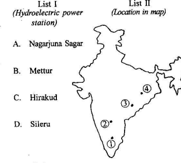
| code | A | B | C | D |
| (a) | 3 | 4 | 1 | 2 |
| (b) | 3 | 1 | 4 | 2 |
| (c) | 2 | 1 | 4 | 3 |
| (d) | 2 | 4 | 1 | 3 |
Page 241 of Lucent GK
- Nagarajuna sagar dam- krishna river AP;
- Mettur- River Kaveri, TN,
- Hirakund – Mahanadi, Orissa
Hence answer (B)
5. Amarkantak plateau in the Maikal hills marks the origin of the river :
- Gandak
- Chambal
- Narmada
- Ghaggar
Answer (C)
- Map @ page10 of India physical environment class 11 NCERT.
- Tata Macgrawhill General Studies Manual, Page 103 under Indian and World Geography
- Page 89, DR Khullar
6. Which of the following statements about Nathu la Pass are correct ?
- It links Sikkim with Tibet
- It was the main artery of the ancient Silk Route
- It was reopened in the year 2006
Select the answer using the code given below:
- 1, 2 and 3
- 1 and 2 only
- 2 and 3 only
- 1 and 3 only
#1 is correct as per various geography books.
- Yes it was reopened in 2006 (Ref this Hindu news item)=3 is correct.
- But was it “main artery” of the silk route? yes according to this xinhuanet report (official press agency of China)=2 also correct.
- Therefore answer 1(A) , 2 and 3 correct.
7. Which one among the following States does not form part of the Narmada basin?
- Madhya Pradesh
- Gujarat
- Rajasthan
- Maharashtra
According to Central Water commission page, Narmada Basin covers only MH, Guj and MP
hence answer (C) Rajasthan is not covered.
8. Which one among the following is the correct sequence of the rivers from north to south ?
- Damodar-Brahmani-Mahanadi-Tungabhadra
- Damodar-Mahanadi-Brahmani-Tungabhadra
- Brahmani-Tungabhadra-Damodar-Mahanadi
- Damodar-Brahmani-Tungabhadra-Mahanadi.
Page 46 of Oxford atlas (or Google maps)
From North to South
- Damodar~W.Bengal
- Bramani~Odisha
- Mahanadi~Odisha
- Tungabhadra~Karnataka|AP
Hence answer (A)
World Geography Answers
1. Which one among the following African countries is not landlocked ?
- Zambia
- Uganda
- Angola
- Zimbabwe
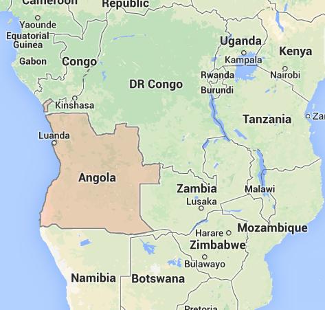
Observe the map of Africa. Angola is a country on the South-western coast of Africa. Not landlocked. Answer (C)
2. Cordillera in North America is a:
- river basin
- high plateau
- inland lake
- mountain system
Britannica: The North American Cordillera is a broad mountain belt extends north from Mexico to Alaska
http://www.britannica.com/EBchecked/topic/394808/mountain/49668/The-North-American-Cordillera
Hence Answer (D)
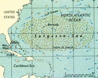
3. Which one among the following is a sea without having a coastline?
- North sea
- Sargasso sea
- Baltic sea
- Bering sea
Ref Page 69 of Oxford atlas.
Another: Sargasso is the only sea without coastline. http://www.gobi.org/Our%20Work/rare-2
4. Statement I: Southern part of France is famous for wine making industry. Statement II: Southern part of France produces a variety of fruits due to Mediterranean climate.
- Both the statements are individually true and Statement II is the correct explanation of Statement I
- Both the statements are individually true but Statement II is not the correct explanation of Statement I
- Statement I is true but Statement II is false
- Statement I is false but Statement II is true
- Britannica page for France:
- Fruit production is largely concentrated in the Rhône and Garonne valleys and in the Mediterranean region=> Statement II correct.
- Wine making are concentrated principally in Languedoc-Roussillon and in the Bordeaux area (Southern France)=>statement I correct.
- Page 10.13 Surinder Singh: Mediterranean regions are rich in land resources. warm temperature ensures a fairly long growing season.=>II explains I.
Hence answer (A)
Geography: Agriculture/soil answers
Q1 Statement I: Typical laterite soils in India are generally fertile. Statement II: Laterite soils generally experience leaching.
- Both the statements are individually true and Statement II is the correct explanation of Statement I
- Both the statements are individually true but Statement II is not the correct explanation of Statement I
- Statement I is true but Statement II is false
- Statement I is false but Statement II is true
NCERT Class 11 Physical geography, page 71
These (laterite) soils are poor in organic matter, nitrogen, phosphate and calcium, while iron oxide and potash are in excess. Hence, laterites are not suitable for cultivation=>Statement I is false.
Therefore, answer (D)
2. Red soil colour is caused by :
- Aluminum compounds
- Mercury compounds
- Iron compounds
- Clay
NCERT Class 11 Physical geography, page 71
The (red) soil develops a reddish color due to a wide diffusion of iron in crystalline and metamorphic rocks. Hence answer (C).
Environment and Biodiversity (EnB)
Curiously, UPSC’s love for Environment biodiversity is rapidly declining for both CDS and CAPF.
| 2012 | 2013 | |
| CSAT | 23 | 22 |
| CAPF | 10 | 5 |
| CDS |
|
3 |
1. Which one among the following is responsible for formation of ‘Ozone Holes’ in the stratosphere?
- Benzopyrene
- Hydrocarbons
- Chlorofluorocarbons
- UV radiation
- The main reason of ozone layer depletion is believed to be the release of chlorofluorocarbon compounds (CFCs), also known as freons.
- Ref. NCERT Class 12 Chemistry, Page 405. (Note: you don’t have to read entire class 12 science books, just selective chapters, listed in the study plan).
2. Which one among the following groups of items contains only biodegradable items?
- Paper, grass, glass
- Wood, flower, iron-scrap
- Sewage, plastic, leather
- Cow-dung, paddy-husk, vegetable wastes
Obviously (D). Because glass=>A wrong, iron=>B wrong, plastic=C wrong.
Interestingly, a similar question is given in NCERT Class 10 Our Environment, Chapter 15
Which of the following groups contain only biodegradable items?
- Grass, flowers and leather
- Grass, wood and plastic
- Fruit-peels, cake and lime-juice
- Cake, wood and grass
3. ‘Silent Spring’, considered by many as one among the greatest science books of all time, is written by Rachel Carson. The book deals with :
- wild life preservation
- protection of the environment
- pollution of the water body
- none of the above
Specifically her books revolves around pesticides. She dealt with following issues:
- the Harmful effects pesticides have on the environment
- Pesticides should properly be called “biocides” because of their impact on organisms other than the target pests.
- Harm DDT inflicted on bird populations and warned of a future spring characterized by the lack of birdsong.
- Highlighted DDT as a chemical carcinogen- causing liver tumors in mice.
Ref: http://www.britannica.com/EBchecked/topic/544081/Silent-Spring
Hence debatable: (B) or (D).
Answerkey for remaining topics soon.
Any correction / wisdom: do post in the comments below.
Courtesy: inputs of Chandra Deo for Geography and Shalini Rai for EnB.
THANK U SIR…
http://www.nih.ernet.in/rbis/basin%20maps/narmada_about.htm
source for questions related to Narmada river.
But now the question arises whether to use OLD or NEW NCERTs. Plz guide…thankyou
Thanks mrunal for supporting Indian youth in a best manner.you are real hero of India…..
The article is good, but should have given explanatory details to some of the questions instead of just giving links.
And Its HCBL Bank, not HBLC bank, as You have written.
i love the way sir explains ,the matter should not be bulky. if you want more details you have to order your hand to click the link. instead of tanking mrunal sir you are raising question on miner mistake ……..grow up u are preparing for upsc
+1 ashish
Earth albedo occurs maximum at the noon time!
Waiting for other sections!thanx mrunal!
hi mrunal im a regular visitor of your site
is ncert books are enough to prepare for CDSE
thank u very much,
u have made us to wait reallyy long for These answers.
all the best for mains writer….
thx sir
Very usefull with detailed analysis
MRUNAL SIR OR ANYONE WHO GVEN MAINS PLEASE CLEAR ONE THING UPSC MAINS KI ANSWER SHEET ME ENGLISH MEDIUM KO QUESTON KEVAL ENGLISH ME HI THE YA HIND VERSION BHI SATH ME THA PLEASE BATANA
HINDI ME BHI THA.
YOU CAN GET THESE PAPER FROM MARKET
VIKAS BHAI THANKS FOR REPLY YE TO ACHCHA HAI KI ANS SHEET ME BHI DONO VERSION DE RAHE HAI
sir answer for question 4 in indian geography section is 3rd option but u r telling it 2, sileru comes at the sea joining course of Krishna and Godavari rivers….
In Indian geo que no 4 answer is worng..
2 is pointed as nagarjuna sagar and 1 as mettur.. so the ans should start with 21**
yes that is my query…answer should be option C
mrunal sir..waha essay 2013 mein…gds nhi gdp aayega…
pls Write in English
my optional is anthropology please
provide me which textbooks i want to read
r u attending sm classes as well???
Thank you Mrunal ji…
answer for the dams {map question} is option ” c ”
it is absolutely right..
in indian geography section, question no.4 is wrongly answered. the answer should be “c” not “b”
for dam question…question no.4 answer is 3
QUESTION 4 OF THE Indian Geography answers:-
ANSWER SHOULD BE (C)..
AS SILERU IS A RIVER IN ODISHA….
Thank you very much sir.,.
answer to ques 4 ( hydroelectric power station) should be (C)