
Classification of Himalayas
Three main geological divisions of India.
- Himalayas, also known as the Extra-Peninsula
- Indo-Gangetic Plains
- Peninsula
Further, Himalayas classified via two methods:
Method #1
- Himalayas are classified, from west to east, into four regions:
- Punjab Himalaya – area between Indus and Sutlej rivers.
- Kumaon Himalaya – area between Sutlej and Kali rivers
- Nepal Himalaya- area between Kali and Tista rivers.
- Assam Himalaya- area between Tista and Brahamputra rivers.
Method#2
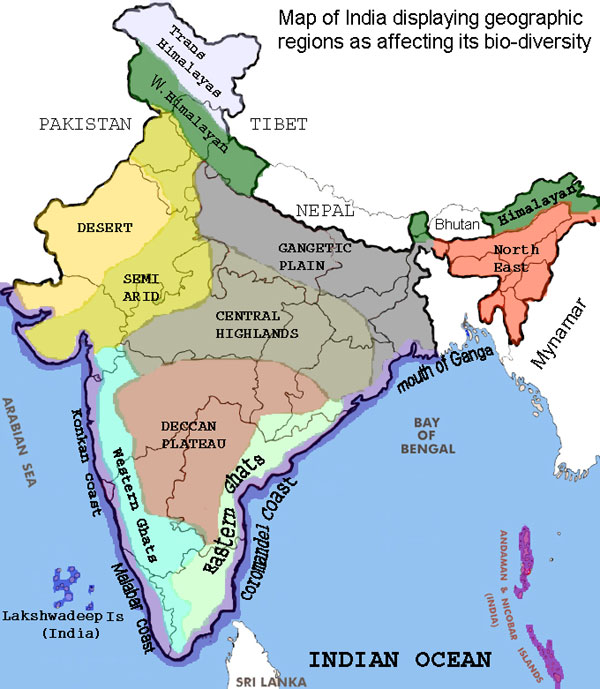
- three regions: the Western, Central and Eastern Himalaya
- Nepal Himalaya constitutes the Central Himalaya and the mountainous area to its west and east are known as Western and Eastern Himalaya respectively
Hazards in the Himalayan Eco-System
- All major types of disasters, prominently
- earthquakes,
- landslides,
- avalanches,
- flash floods
- forest fires
- soil erosion
| Altitude | Type of disaster |
|---|---|
| Over 3500m | snow avalanches and glacial lake outburst floods (GLOFs) |
| 500 to 3500 m | flash floods; landslides and mudflows |
Landslides: Reasons
- indiscriminate chopping down of trees.
- slash and burn cultivation technique called ‘JHUM,’
- Road construction and mining.
- Every increasing population, grazing, urbanization etc. has destroyed the dense natural evergreen forest cover.
Such activities have disrupted the ecological balance, thereby resulting in loosening of the soil. During the heavy rain, this leads to soil erosion and frequent landslides
Landslides: Damage
- Every year, landslides in the region kill dozens of people and cause widespread damage to several villages such that they have now become almost unfit for habitation.
- They create blockades in the road network and river system, which in turn, cause floods.
- The terraced farm fields have been destroyed that cannot be easily renovated or made productive again.
- The road network remains closed for long periods causing indescribable hardship to the villagers who get their basic supplies and provisions from the neighbouring areas.
- Water sources are disrupted and chocked by debris from landslides.
- The river sediment load is increased considerably, causing irregular courses and frequent breaching of the banks- resulting into unexpected floods.
- The water channels are affected from the up hillside due to which the villagers are devoid of water for irrigation purposes. This adversely affects agriculture production in the region.
Suggestions to fix problem
- Store Excess water in catchments areas to reduce the fury of flash floods, recharge the ground water and improve the environment.
- Dig runoff collection ponds in the catchments.
- Grow fuel / fodder trees in all of the common lands.
- Plantation in barren areas, especially on slopes, with grass cover is an important component of integrated watershed management programme.
- Grazing should be completely restricted. After the area is completely protected from grazing, better grasses can be planted.
- The grasses of industrial importance should also be planted so that there is some economic return to the farmers as well.
- Use the surface vegetative cover to protect the land from raindrop’s beating action, bind the soil particles and decrease the velocity of flowing water.
Reference: IGNOU MPA 018/Chapter 3.
Avalanche Mitigation
Topic in news because in April 2014, ~dozen Nepali Sherpa died during an avalanche in Mt. Everest base camp. This lead to protests and other sherpas refusing to guide the tourists.
Q. List the factors responsible for avalanches and suggest disaster mitigation measures. (200 words)
Rapid downslope movement of snow, rocks and debris- is called Avalanche.
Large avalanches have speed of upto 200kmph, resulting in massive destruction of forests, highways, houses and power lines.
Factors
Whenever gravitational force exceed the mechanical strength of snow cover- avalanche occurs. This happens by “triggers”- natural and artificial
| Natural triggers | Artificial triggers |
|
|
Mitigation in Avalanche prone Areas
- Don’t construct buildings for winter occupancy
- Avoid construction of power lines, highways and railroads. It they must be constructed then design for minimum impact.
- It is possible to forecast avalanche, by studying Snow deposition data, heat input, slope angle.
- Use Remote sensing technology & satellite imagery to obtain such data.
- Only allow agriculture and recreational activities during summer and spring.
- Use explosives to create smaller, controlled avalanches and thus avoid building up of snow for large unpredictable destructive avalanches.
- Quick response teams (QRT) from local administration and NDRF, with standard Avalanche equipment and devices like GPS, Radio Beacons, shovels and sniffer dogs.
~180 words.
Already done:
- Snow and Avalanche Study Establishment (SASE) : forecasts snow avalanches
- Border road organization (BRO): keeps the highway paths clear after avalanches- particularly the Rohtang Pass and Baralachla Pass.
Factoids:
- Most Avalanche victims die of suffocation (lack of oxygen) and not hypothermia (extreme cold temperature)
- After 35 minutes, the survival chance is 30%
- After two hours, survival change is ~0%
- Therefore self-rescue or companion rescue is vital, because NDRF / sarkaari help will take hours to reach.
Mock MCQ: Which of the following can cause avalanches?
- Shouting
- sonic booms
- Earthquakes
Answer choice
- Only 3
- Only 1 and 3
- Only 2 and 3
- All of them
![[Environment] Mangrove Species Conocarpus banned in Gujarat & Telangana](https://mrunal.org/wp-content/uploads/2023/09/edp-conocarpus-500x383.png)
![[Environment] Floating Solar Farms, Banni Grassland, Nairobi flies & more Weekly Mrunal Digest from Jul week1-2022 (WMD)](https://mrunal.org/wp-content/uploads/2022/07/Floating-Solar-Farm-500x383.webp)
![[Environment WMD] Single use plastic ban, ESZ, Surya Nutan Cooker, & more from Jun week3-2022](https://mrunal.org/wp-content/uploads/2022/07/single-use-plastic-main-500x383.jpg)
![[T25] UPSC Mock Round#43: Environment & Geography Practice Questions- Global Climate Risk Index 2020, Bog wetland and More](https://mrunal.org/wp-content/uploads/2018/12/c-t25-taimur-500x383.jpg)
i really appreciate your way of understanding regarding the topics.And these are very useful for quick revision and brief knowledge.
sir,
an error 500 internal server error occured while using ur website. ur website is of gr8 help to me, so please help me by letting me kno anything i might have done that may have caused the error.
MRUNAL YOU ARE TRUELY A BLESSING FOR ME.MAY THE GOOD GOD BLESS YOU AND GUIDE YOU ALWAYS
MRUNAL COULD U PLEASE EXPLAIN THE CLIMATIC FEATURES AND SOIL OF INDIA….
Mrunal Sir, Thanks for your notes.I found it really helpful.
im revising upsc preims part if wanna join with ur hands just follow my gmail vish123123@gmail.com
Sir
How erosion can be termed as a disaster, it is a very slow process and thus can be termed as a cause of disaster.
sir, i want the info. about the top 6 worst landslides in india since 1970, pls help !!!
nonsense
Mrunal sir-thanks a lot
thnk u sir …it helped me greatly !!!
thanks a lot mrunal sir …………………
hello sir….thank you for the information on avlanches in the present disaster topic with a brief background info on himalayas…..kindly supplement it with the info on present disaster of Nepal earthquake……as you provide a very to the point information (a fact highly appreciated)…..
sir for this prelim for environment the material you provided is all to be done as such given or the topics like disaster,fauna flora,agri,energy polution are will be covered by current study?
sir plz reply.
thanku
sir for this prelim for environment the material you provided is all to be done as such given or the topics like disaster,fauna flora,agri,energy polution are will be covered by current study?
sir plz reply.
thanku
Thank you sir and madam for your lectures of economy and geography .. it is a great help .. and also thanks for guidance for preparation of upsc.. your test series .. your notes they are really helpful to students of remote places and poor financial condition due to which they cannot afford highly paid coachings.. I wish we could have such lectures for others subjects too..
Sir i want know reasonand solution of himalayan region’s earthquake and landslides and i also know all list of effected region in details by a chart.
You give already all possible quietuses answer .I appreciate you and your organisation .
Thanking you.
. Depth explanation . Thanks sir
good.
thank you sir..